![]()
![]()

 Presentation
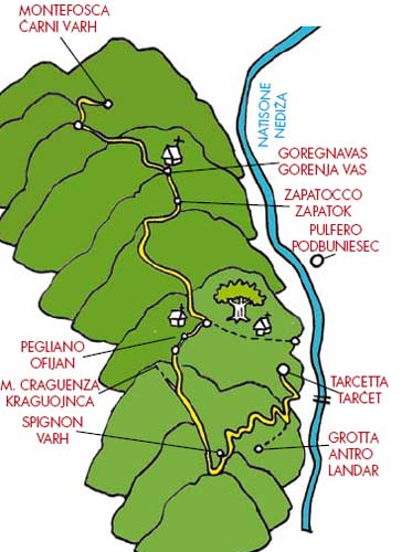
Panoramic itinerary that from the Natisone/Nediža valley floor reaches Montefosca/Čarni Varh set between Mounts Joanac/Ivanac, Lubia/Ljubja and Mia/Mija.
Description of the route
From Tarcetta/Tarčet climb up to Spignon/Varh and take the country road for Pegliano/Ofijan. Then continue along the country road to Zapatocco/ Zapatok and Goregnavas/Gorenja Vas, to finally take the country road towards Montefosca/Čarni Varh approximately 4km.
Length
The total length of the route is approximately 16km. Here are the kilometres of each section:
Tarcetta/Tarčet – Antro/Landar 1.2km;
Antro/Landar-Spignon/Varh 3km;
Spignon/Varh-Cocianzi/Kočjanci approximately 3km;
Cocianzi/Kočjanci-Goregnavas/Gorenja Vas approximately 4km;
Goregnavas/Gorenja Vas- Montefosca/Čarni Varh 4km.
Altitude
Approximately 600 metres. Altimetry:
Tarcetta/ Tarčet 221m;
Church of S. Spirito 680m;
Cocianzi/ Kočjanci 568m;
Goregnavas/Gorenja Vas 680m;
Montefosca/Čarni Varh 707m.
Level of dificulty:
Medium


From Slovenia: by car drive from Kobarid/ Caporetto to Italy across the Robič pass towards S. Pietro al Natisone/Špietar. After 17km turn right, cross the bridge on the Natisone/Nediža and keep to the right for 500 metres, up to Tarcetta/ Tarčetta.
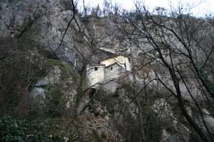
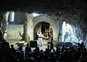
From Tarcetta/Tarčet, on the right-hand side of the Natisone/Nediža, the tarmac road (with a short hill) (1.2km) leads to Antro/Landar, the small village with the famous cave of S. Giovanni/ Landarska Jama.

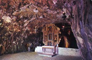 climbs along a rocky wall. At the top, through a narrow door there is the first big hall of the Antro/ Landar cave. In 1477 (seen on the right) the master builder Andrea von Lack set into the rock the splendid church of S. Giovanni d’Antro (Saint John of Antro), embellished in the 17th Century by a wooden altar by Bartolomeo Ortari. Across a system, (not yet all explored) of galleries and halls, also on different levels, the cave twists and turns for 5 kilometres. Rich with subterranean springs, it still contains the remains of animals, amongst which is the Bear of the caves. The first section is open to tourists - it is possible to have a guided tour with an authorised guide from the local speleological club by contacting the Pro loco “Nediške Doline-Valli del Natisone” (tel. 338/1260311; info@nediskedoline.it; www. nediskedoline.it).
Return to the tarmac road and proceed upwards.
After approximately 500 metres, having passed a
big widening, at the first crossroad turn left, here
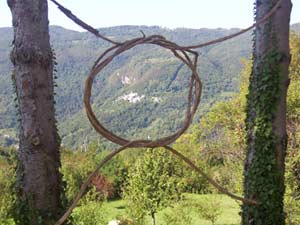
the woods clear offering pleasant views towards
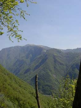
Matajur and its long gradually sloping ridge.


The road passes under the small hamlet of Spignon/ Varh, (3 km from Antro) and arrives at another junction (intersection with itinerary 11. See page 105). To the left a short digression takes to Puller/ Pulerji where there is a farmhouse trattoria.
Take the dirt track on the right that comes from Cividale/Čedad and proceeds towards Masarolis/ Mažeruola. Here we are on the wide grassy ridge of Craguenza/ Kraguojnca, which has not yet been invaded by woods and therefore still preserves (thanks to the heroic dedication of the few families left devoted to a mountain agriculture poor of profit but rich in landscape value) the aspect of a well-kept garden, with its scattered birches, one or two tall trees silhouetted against the sky and the nearby linear outline of Matajur in front. Avoid all roads to the left, our path leads away from the ridge and goes into the woods. In addition what now appear to be woods in reality used to be “meadows of trees” that slowly turned into orchards or even terraced vine fields near the villages. The eastern slopes of Mount Craguenza/Kraguojnca open into a large creek where, at 600m above sea level, the picturesque villages of Cedermas/Čedarmači, Floram/Flormi, Stonder/Štonderi, Cocianzi/ Kočjanci, Dorbolò/Dorbolì, Sosgne/Šošnja are situated; all together these form the collective
name of Pegliano/Ofijan.

 remains of the ancient church of San Nicolò/Sv. Miklav¡ are found a little further on, after a wood of beeches.
Having arrived at Cocianzi/Kočjanci, a board
indicates the big chestnut tree over a hundred years. old, which is our true destination. Take the forest
road that follows the side of the mountain, pass
near an apple orchard, and fields and meadows
which are still cultivated, then enter the woods.
Descending on the right using the fairly wide
tractor trail of the Galobica ridge it is possible
to reach the beautiful little church of San Donato
(Saint Donatus) (1.5km) and down to Lasiz/Laze
(approximately 2km). After approximately 1km
beyond the Jauarščak stream, on the left a wide
paved mule track separates. Take this road for
approximately 300 metres and you find yourself
in the heart of a chestnut wood that has been
abandoned for at least 30 years.
Here, a little higher, marked by a signpost, there
is the gigantic chestnut tree; circumference of 7.1 metres and 24 metres high. Its presumed age is 300
years. Other trees surrounding this one also have
considerable dimensions and are worth noting.
Follow the main path, for a little less than 2km up
to the end of the tarmac road
Pulfero/Podbuniesac-
Montefosca/Čarni Varh, a little after the village
of Zapatocco/Zapatok. At this point, follow  the
tarmac road to the left for 1km and without going
up towards Calla/Kau go to Goregnavas/Gorenja
Vas, an idyllic oasis with terraced fields cultivated
with potatoes and beans, interlaced with roses
and people who make hay. From here, continuing
straight, you are once again on a forest road that in
summer is like a real green tunnel. The road enters
the deep valley of the Bodrino/Budrin stream; here
a few sections have a marvellous view overlooking
the Natisone/Nediža (with bench). It is a route that
has only recently been completely marked by Cai
trail signs. About Halfway through the route there
is a junction with a sign for the church of S.Andrea
(Saint Andrew) and takes about thirty minutes. Pass
the Bodrino/Budrin river over an old stone bridge
and you will shortly reach the village of Paceida/
Pačejda and Montefosca/Čarni Varh.
the
tarmac road to the left for 1km and without going
up towards Calla/Kau go to Goregnavas/Gorenja
Vas, an idyllic oasis with terraced fields cultivated
with potatoes and beans, interlaced with roses
and people who make hay. From here, continuing
straight, you are once again on a forest road that in
summer is like a real green tunnel. The road enters
the deep valley of the Bodrino/Budrin stream; here
a few sections have a marvellous view overlooking
the Natisone/Nediža (with bench). It is a route that
has only recently been completely marked by Cai
trail signs. About Halfway through the route there
is a junction with a sign for the church of S.Andrea
(Saint Andrew) and takes about thirty minutes. Pass
the Bodrino/Budrin river over an old stone bridge
and you will shortly reach the village of Paceida/
Pačejda and Montefosca/Čarni Varh.
