![]()
![]()


Presentation
This route is fascinating as you discover the ridge
between the Iudrio/Idrica and the Erbezzo/Arbeč
valleys, via Sentiero Italia.
Description of the route
Departure from Albana/Albane and climb, along
Sentiero Italia, up to Castelmonte/Stara Gora.
Round to Tribil di Sotto/Dolenj Tarbij, Presserie/
Preserje, and country road for Polizza/Polica and
Tribil Superiore/Gorenj Tarbij.
Length
The total length of the route is approximately
26km. The kilometres for each section are:
Albana/Albane-Cladrecis/Seucè.approximately.4km; Cladrecis/Seucè-Castelmonte/Stara Gora
approximately 5.5km; Castelmonte/Stara.Gora-Presserie/Preserje.
approximately 11km;
Presserie/
Preserje-Polizza/Polica approximately 3.5km;
Polizza/Polica-Tribil Superiore/Gorenj Tarbiji
approximately 1.5km.
Altitude
Approximately 900 metres. Altimetry:
Albana/
Albane 104m;
Cladrecis/Seucè 250m;
Castelmonte/
Stara Gora 618m;
Presserie/Preserje 496m;
Polizza/
Polica 550m;
Tribil Superiore/Gorenj Tarbij
642m.
Level of dificulty:
Medium

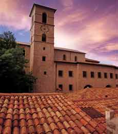
 according to the rules of the Slovenian school. It has two sections: on the lower section there are the figures of the Madonna with child, Saints Peter and Sebastian, and on the upper section Saint Anthony Abbot, Anne with Mary as a child and Joachim. There are also paintings by Girolamo Ridofli from Cividale (Madonna with child and Saints Peter and Paul, already an altar piece, 1585) and by Francesco Colussi (Adoration of the Magi, 1777).
A little beyond Centa/Britof there is the trail marked with CAI trail sign n°748. After
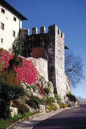
approximately 500m along this trail it starts to climb towards left (1). However if you continue on the small road, in a few minutes, you arrive at Albana castle belonging to the Gabrici family. From here follow a long steep track in the semibarren woods until you reach a field near a tarmac road free from traffic. Take the road to the right and following the red and white Cai trail signs pass over Cladrecis/Seucè (farmhouse) and reach Stregna/Srednje di Prepotto/Prapotno and Fragielis/Frideu, impressive little villages facing the Iudrio/Idrija Valley. A few hundred metres before the church of Fragielis/Frideu go left (look out for the indications) and continue to follow Sentiero Italia which now proceeds along the mountain to then reach the church of the Tre Re/Trije Kraji (Three Kings) (intersection with itinerary n° 4, see page 41), 530m, and then on the dirt road to Castelmonte, 618m. (intersection with itinerary n° 2. See page 24).
Caution! The last part of the path before the church is steep and rocky, not very suitable for horses. This section can be easily avoided by following an old mule track, marked by a dashed black line on the Tabacco map. This track goes round the sector in the woods, breaking off from Sentiero Italia on the left.
Quick alternative:
from point (1) turn left, enter the hamlet of S.Pietro di Chiazzacco/Tieje, climb up, using the wide mule track, on the ridge up to 456m and then follow the tarmac road, free from traffic, up to Castelmonte/Stara Gora.

Go along a section of the main road until a little
past the crossroads of Iainich/Jagnjed (607m)
and via fields climb up to the nearby peak and
once passed near a house there the are red and
white Cai trail signs once again (caution: the
new 2005 indications are not consistent with the
map). Always stay on the north side of Mount S. Nicolò/Sv. Miklavž and you reach the church in
approximately 670 metres.


 With the new indications the path (easy) continues
on the north side and, without completely
descending to Covacevizza/Kovačeuca, continues
through the woods, always in view of the tarmac
road a little below, until arriving to the tarmac
With the new indications the path (easy) continues
on the north side and, without completely
descending to Covacevizza/Kovačeuca, continues
through the woods, always in view of the tarmac
road a little below, until arriving to the tarmac
road in front of the forest road at Skriuca. Take
a mule track that descends into the valley (the
path is marked in black on the map) and you will
shortly arrive at the fields of Planino, scattered
with stavoli of a curious architecture, near Tribil
di Sotto/Dolenj Tarbij.
Arrived at Tribil di Sotto/Dolenj Tarbij, where
unfortunately for the moment there is no restaurant,
continue on this road for approximately another
700m towards Tribil di Sopra/Gorenj Tarbij (it
is possible to avoid a section of tarmac road by
staying on a dirt road a little below. In addition
there are other beautiful fields and a big drinking trough cut out of a block of stone dating from
1850) and next to a hayloft, on the left, descend
into the wood of chestnut trees via a small path to
reach Presserie/Preserje. Follow the map carefully
in this section as the route is not marked even
though it is very visible.
At Presserie/Preserje take the large and rather long
dirt road that, with lots of little hills, goes over
the numerous watersheds of the Erbezzo/Arbeč.
At the beginning there is a beautiful view that
overlooks the village of Oblizza/Oblica situated
on the opposite side. After having completely
gone round the ridge where the village of Polizza/
Polica is situated, the forest road joins from the
north. In the village avoid following the tarmac
road towards Gnidovizza/Gnjiduca and go onto the
mule track right at the beginning of the village. In
only a few minutes there is the main road heading
towards Tribil di Sopra/Gorenj Tarbij with its strange bell tower which looks like an embattled
turret. Having passed the ex-dairy building go up
to the village on the right using a little road that
passes in the middle of the houses..
CONECTION OF ITINERARY 3 WITH ITINERARY 1:
unfortunately from Tribil di Sopra/Gorenj Tarbij Sentiero Italia towards Drenchia/Dreka can no longer be crossed via horse. Wanting to go therefore to Clabuzzaro/Brieg via Itinerary 1 on page 19, which goes up from the Iudrio/Idrija valley it is necessary to follow the tarmac road, free from traffic, for 7km from Tribil di Sopra/ Gorenj Tarbij to Clabuzzaro/Brieg. If necessary it is possible to go down into the Iudrio/Idrija valley via two different forest roads, one direct from Tribil di Sopra/Gorenj Tarbij and one that departs from Gnidovizza/Gnjiduca and goes down along Gostlaz. Also from Rucchin/Zaločilo there is a forest road that goes down to the Iudrio/Idrija River.