![]()
![]()

.Presentation
A rather long itinerary, but of extreme interest and easy to do. Advised to be done in spring and Autumn. Of historical (on mount Craguenza/ Kraguojnca and Mladesiena the Vicenza Brigade was assembled, which was attacked and was had to surrender on the 27th October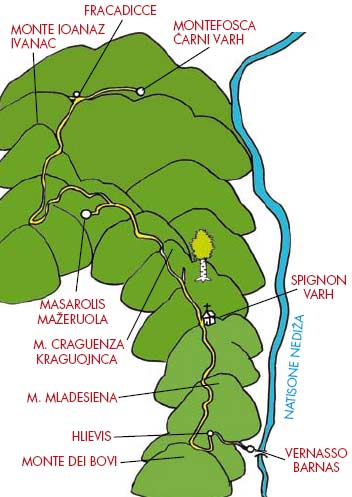 1917), naturalistic (the
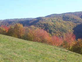
remarkable fields of Mount Craguenza/Kraguojnca
and the old chestnut tree of Pegliano/Ofijan) and
1917), naturalistic (the
remarkable fields of Mount Craguenza/Kraguojnca
and the old chestnut tree of Pegliano/Ofijan) and
landscape (splendid panorama overlooking the Friulian plain and the Alps) interest.
Description of the route
From Vernasso/Barnas take the country road of Monte dei Bovi and reach the little church of S. Spirito/Sv. Duh (The Holy Spirit) at
Spignon/ Varh, Mount Craguenza/Kraguojnca, the col of Calla/Kau, the col of Masarolis/Mažeruola, and then the country road for Montefosca/Čarni Varh or for the farmhouse da Zaro in Farcadicce (possible climb to Mount Joanaz/Ivanac).
Length
The total length of the route is approximately 16km. Here are the kilometres for each section:
Vernasso/ Barnas-Hlievis approximately 3km;
Hlievis-S. Spirito/Sv. Duh approximately 6.5km;
S. Spirito/ Sv. Duh-Craguenza/Kraguojnca approximately 3km;
Craguenza/Kraguojnca - Joanaz/Ivanac approximately 3.5km.
Altitude
Approximately 1000 metres up to Mount Joanaz/ Ivanac. Altimetry:
Vernasso/Barnas 162m;
Hlievis 300m;
Monte dei Bovi 435m;
church of S. Spirito Sv. Duh 680m;
the slopes of Craguenza/ Kraguojnca, 888m;
Bocchetta di Calla/Kau 866m;
Monte Joanaz/Ivanac 1167m.
Level of dificulty:
Medium
A rather long itinerary, but of extreme interest and easy to do. Advised to be done in spring and Autumn. Of historical (on mount Craguenza/ Kraguojnca and Mladesiena the Vicenza Brigade was assembled, which was attacked and was had to surrender on the 27th October
1917), naturalistic (the
remarkable fields of Mount Craguenza/Kraguojnca
and the old chestnut tree of Pegliano/Ofijan) andlandscape (splendid panorama overlooking the Friulian plain and the Alps) interest.
Description of the route
From Vernasso/Barnas take the country road of Monte dei Bovi and reach the little church of S. Spirito/Sv. Duh (The Holy Spirit) at
Spignon/ Varh, Mount Craguenza/Kraguojnca, the col of Calla/Kau, the col of Masarolis/Mažeruola, and then the country road for Montefosca/Čarni Varh or for the farmhouse da Zaro in Farcadicce (possible climb to Mount Joanaz/Ivanac).
Length
The total length of the route is approximately 16km. Here are the kilometres for each section:
Vernasso/ Barnas-Hlievis approximately 3km;
Hlievis-S. Spirito/Sv. Duh approximately 6.5km;
S. Spirito/ Sv. Duh-Craguenza/Kraguojnca approximately 3km;
Craguenza/Kraguojnca - Joanaz/Ivanac approximately 3.5km.
Altitude
Approximately 1000 metres up to Mount Joanaz/ Ivanac. Altimetry:
Vernasso/Barnas 162m;
Hlievis 300m;
Monte dei Bovi 435m;
church of S. Spirito Sv. Duh 680m;
the slopes of Craguenza/ Kraguojnca, 888m;
Bocchetta di Calla/Kau 866m;
Monte Joanaz/Ivanac 1167m.
Level of dificulty:
Medium


Depart from Vernasso/Barnas (find a suitable
place to park vehicles, for example in the zone
where festivals take place).
From Italy: Arriving from Cividale/Čedad on
main road n°54, once entered from S. Quirino/
Muost bridge turn left before crossing the

 Natisone/Nediža bridge. Having arrived at a crossroad with an ancona in the middle turn left. From Slovenia: Arriving from Kobarid/
Caporetto on main road n°54, once crossed S. Pietro al Natisone/Špietar, turn right towards Vernasso/Barnas. Having arrived in the square turn left and then, near the crossroad with an ancona in the middle, turn right.
Natisone/Nediža bridge. Having arrived at a crossroad with an ancona in the middle turn left. From Slovenia: Arriving from Kobarid/
Caporetto on main road n°54, once crossed S. Pietro al Natisone/Špietar, turn right towards Vernasso/Barnas. Having arrived in the square turn left and then, near the crossroad with an ancona in the middle, turn right.In this village the little church of S. Bartolomeo
(Saint Bartholomew) is worth noting. Dating from
the late 15th Century it was restructured in
the 16th Century in a Slovenian gothic style by artists from the school of Škofija Loka. The series of frescos by the painter Jernej iz Loke (Bartolomeo from Škofija Loka) stand out (a gallery of apostles, martyred saints and virgins, all dated 1530) and the splendid golden altar, richly decorated, by the carver master Jernej Vrtav (Bartolomeo Ortari) from Caporetto, dating from 1689.
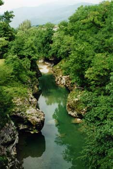
Climb up along a dirt road (unfortunately not suitable for cars with horse trailers) into the valley of the Patok stream. At the beginning of the hill it is worth stopping to imagine the bottom station of the twelve-cable cableway which was used to take, from the mountain to the valley floor, the products of people’s labour from Vernasso/ Barnas, in particular hay and straw. After 2.8km, at the junction there are bilingual notices: follow the direction Cividale/Čedad and Puller/Pulerji. Another 300 m and you reach Hlievis farmhouse, an old farmhouse abandoned after the First World War today admirably restructured and situated in a beautiful position. Walking in the old village square it is still easy to imagine the three large families that lived there with their numerous children, and that in this place they were able to find their livelihood. From here, follow for a long period of time the forest road that has no historical value; it was built in the 80s by the Commune of
S. Pietro al Natisone. Without taking any of the paths and mule tracks that spring up to the left and right here and there entering the woods, and by being very careful at 403 above sea level, you will find a junction with a sign indicating to go right in the direction of Cividale/Čedad and Puller/ Pulerji.
Here we encounter the military road with a
junction; this road was built during the First
World War to link Cividale/Čedad (Rubignacco)
with the artillery posts of the Italian third defence line. Characterised by a deposit of stones and pebbles, 2.30 metres wide, it was builtwith a constant and slight slope to allow men, horses and oxen to take cannons, munitions and provisions for the soldiers.
Turning left (only on foot, not advised on horse) you shortly reach the artillery posts of Monte dei Bovi (Mont dai Bus in Friulian, Volovjak in Slovenian, Uresberg in German), a peak (435m) positioned right on top of the big quarry of Vernasso, from which there is a beautiful panorama of almost all of the Italian defensive lines of the First World War.
Turning left (only on foot, not advised on horse) you shortly reach the artillery posts of Monte dei Bovi (Mont dai Bus in Friulian, Volovjak in Slovenian, Uresberg in German), a peak (435m) positioned right on top of the big quarry of Vernasso, from which there is a beautiful panorama of almost all of the Italian defensive lines of the First World War.
In the background you can see the impressive
outlines of Mount Krn (Monte Nero for Italians)
and Mount Batognica (Monte Rosso for
Italians), Italian bridgeheads in the Caporetto area, and further back, descending from the top of Matajur towards the right (East) the profile
of the ridge of Kolovrat, of Mount Cum/Hum (with its characteristic shape of a pyramid) and Castelmonte/Stara Gora. Looking at the large
square, it is possible to see the remains of the retaining walls and containment walls secured into the ground which were necessary for the protection of weapons.
Return to the junction (where, if needs be, we have left our horses) and turn left following the indications for Cividale/Čedad and Puller/Pulerji that skirt the west side of the mountain. Even those who are not experts will notice the good condition of this historical road that has a lot to teach even to the new constructions of modern roads. On the left the Friulian plain and Cividale/Čedad are seen in all their splendour. After a little more than 1.5km, 407m above sea level, take the direction that comes from Cividale/Čedad. Take it towards the right and follow it for a length of time along the west side of Mount Mladesiena; it has a beautiful view overlooking the Torreano/ Tauarjana and Chiarò valleys. Going up, 553m above sea level, on the left there is a small barrack near the junction for Bučija Jama. Stopping for a moment, it is possible to notice in front a heap of earth with a small chimney and other similar buildings nearby; this time they are bunkers from the Cold War which have left their sign. Not taking any of the roads that descend you reach a small col 660m above sea level, with a crossroad. From the junction of Monte dei Buoi you have travelled approximately 3.5km.
Taking the first road on the right, climb (advisable only on foot and not on horse) up to the top of Mount Mladesiena (711 metres), this is fairly short.
Instead, taking the second right, after a few metres, there is another junction. (Intersection with itinerary n° 10. See page 96).
On the summit to our left hides the small votive Art
church dedicated to the Spirito Santo/Sveti Duh
(Holy Spirit), not visible from the road.

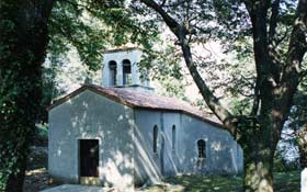 On the field an uphill track leads towards the small woods on the top, inside of which there is the small building of the old (15th Century) church(rebuilt after the Second World War) of S. Spirito (Holy Spirit) which lies in a basin of grand lime trees. This hidden place is worth a visit.
Turning right at the junction, and leaving to the left the road that descends to
 Spignon/Varh, after
300m there is a drinking water fountain a little
before the houses of the hamlet of Puller/Pulerji
where there is also a farmhouse restaurant.
Spignon/Varh, after
300m there is a drinking water fountain a little
before the houses of the hamlet of Puller/Pulerji
where there is also a farmhouse restaurant. Return to the crossroad and take the Antro/Landar- Spignon/Varh-Pegliano/Ofijan path on the left.
From the small col, (altitude 660m), continue North-west along the dirt road now almost flat (with a short tarmac section). Not taking the road on the left that takes to Masarolis/Mažeruola, go up following the clearly visible and picturesque route along the meadowy ridge of Mount Craguenza/ Kraguojnca. After approximately 300m there is the first junction on the right not to be followed (road for Pegliano/Ofijan).

Deviating to the right it is possible to admire the
historical chestnut tree at Pegliano/Ofijan. See
itinerary 10 on page 98.

After another 300m there is a second crossroad:
leave on the right a road that re-links with the
previous road.
Climb up along meadows towards the south peak of Mount Craguenza/Kraguojnca, 912m. After a fairly flat section leave the main peak on the right and descend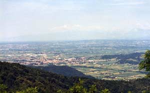 towards the col of Calla/
Kau, 866m, via the steep but visible path. From
here, always continuing North-west you reach,
in approximately 100 metres, the tarmac road
that comes from Masarolis/Mažeruola. Follow
this road uphill to the small barrack and from
here again on the dirt road north-westward up to
the col of Masarolis/Mažeruola, 800m. Having
passed this, the road starts to skirt descending
slightly along the west side of Mount Joanaz/
Ivanac (with a small, not perennial, spring).
After a couple of kilometres, having left on the
left the road that goes round the north side of Mount Joanaz, in approximately 2km you reach
the farmhouse Da Zaro, 640m.
towards the col of Calla/
Kau, 866m, via the steep but visible path. From
here, always continuing North-west you reach,
in approximately 100 metres, the tarmac road
that comes from Masarolis/Mažeruola. Follow
this road uphill to the small barrack and from
here again on the dirt road north-westward up to
the col of Masarolis/Mažeruola, 800m. Having
passed this, the road starts to skirt descending
slightly along the west side of Mount Joanaz/
Ivanac (with a small, not perennial, spring).
After a couple of kilometres, having left on the
left the road that goes round the north side of Mount Joanaz, in approximately 2km you reach
the farmhouse Da Zaro, 640m.
Possible links: Towards Montefosca/Čarni Varh with possible descent into the Natisone/Nediža valley (difficult). Towards Prossenicco/Prosnid and Campo di Bonis.
Climb up along meadows towards the south peak of Mount Craguenza/Kraguojnca, 912m. After a fairly flat section leave the main peak on the right and descend
towards the col of Calla/
Kau, 866m, via the steep but visible path. From
here, always continuing North-west you reach,
in approximately 100 metres, the tarmac road
that comes from Masarolis/Mažeruola. Follow
this road uphill to the small barrack and from
here again on the dirt road north-westward up to
the col of Masarolis/Mažeruola, 800m. Having
passed this, the road starts to skirt descending
slightly along the west side of Mount Joanaz/
Ivanac (with a small, not perennial, spring).
After a couple of kilometres, having left on the
left the road that goes round the north side of Mount Joanaz, in approximately 2km you reach
the farmhouse Da Zaro, 640m.Possible links: Towards Montefosca/Čarni Varh with possible descent into the Natisone/Nediža valley (difficult). Towards Prossenicco/Prosnid and Campo di Bonis.