![]()
![]()

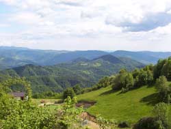
This is a panoramically beautiful itinerary along the valleys of the Cosizza/Kosca, Iudrio/Idrija and Rieca/Rieka streams with a visit to the
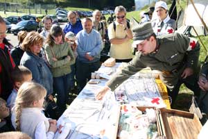
 trenches
and recollections of the First World War.
trenches
and recollections of the First World War.Description of the route
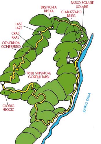
From Clodig/Hlodič up to Tribil Superiore/Gorenj Tarbij and then to Podlach/Podlak. From here down along the Iudrio/Idrija valley up to Clabuzzaro/ Brieg and Pass Solarie/Solarje. After having crossed the ridge of Mount Kolovrat, back down to Clodig/ Hlodič along the Rieca/Rieka stream valley.
Length
The total length of the route is approximately 31km. Here are the kilometres for each section:
Clodig/ Hlodič-Tribil Superiore/Gorenj Tarbij 6km;
Tribil Superiore/Gorenj Tarbij-Iudrio/Idrija valley floor 5km;
Iudrio/Idrija valley floor-Clabuzzaro/Brieg approximately 7km;
Clabuzzaro/Brieg-Solarie/ Solarje 1,5km;
Solarie/Solarje-bivouac Zanuso 2km;
bivouac Zanuso-Drenchia/Dreka 1km;
Drenchia/Dreka-Clodig/Hlodič 8,5km.
Altitude
Approximately 1130 metres. Altimetry:
Clodig/ Hlodič 253m;
Tribil Superiore/Gorenj Tarbij 642m;
the Iudrio/Idrija valley floor 328m;
Clabuzzaro/Brieg 802m;
Solarie/Solarje 958m;
bivouac Zanuso 1065m.
Level of dificulty:
Elevated as a result of the altitude, which can however be reduced to .800m with the alternatives advised here below.
 |
 |
From Clodig/Hlodič, cross the bridge on the
Cosizza/Kozca stream (at the beginning of the
town, on the left, turning away from the road that
goes down towards Liessa/Liesa) go up 6km up to
Tribil Superiore/Gorenj Tarbij (for trenches and
recollections of the First World War see page 28) passing through Podlach/Podlak.
Intersection with itineraries n° 2 (see page 28), n° 3
(see page 37) and n° 4 (see page. 43).
Always continuing straight towards Castelmonte/
Stara Gora, turn left after 2.5km and go across
the village of Gnidovizza/Gnjiduca. Soon after
leaving the village, on the left there is a dirt road
that goes down to the Iudrio/Idrija stream valley,
approximately 2km. Reached the valley floor, by turning left we intersect with itinerary n° 1 (see
page 19) that goes along the Ponte Clinaz/Pod
Klanec-Clabuzzaro/Brieg path, up the course of
the stream and acts like a border with Slovenia.
From Clabuzzaro/Brieg (intersection with itinerary
n° 2, see page 29) take Sentiero Italia (marked
with the red and white Cai trail sign n° 746) up
to the Solarie/Solarje refuge (intersection with
itinerary n° 6. Trenches and recollections of the
First World War. See page 58).
ALTERNATIVE: having done the hill and after
Podlach/Podlak, it is possible to turn left onto
the tarmac road and without going down into
the Iudrio/Idrija valley, reach Solarie/Solarje by
crossing through Rucchin/Zaločilo, San Volfango/
Sv. Štuoblank and Clabuzzaro/Brieg.


 Taking once again the main route. From Solarie/
Solarje cross the ridge of the Kolovrat (following,
at pleasure, one of the suggestions in itinerary
n° 6. see page 61). Reach bivouac Zanuso via the Italian tarmac road. From there a marked
path leads downhill to Drenchia/Dreka and then
turning right onto the tarmac road cross Lase/
Laze, Cras/Kras (3km) and Oznebriba/Ocneberdo
(another 500m). Having left this village after
approximately 300m the road begins to go up
towards Trusgne/Trušnje. Turning left there is
immediately a junction where you can to decide to
go down using either path: left towards Paciuch/
Pacuh (longer, approximately 4 km) or right
towards Peternel (shorter, approximately 3 km, and steep). Return to Clodig/Hlodič on the tarmac
road: from Paciuch/Pacuh 3,5km, from Peternel
2 km.
Taking once again the main route. From Solarie/
Solarje cross the ridge of the Kolovrat (following,
at pleasure, one of the suggestions in itinerary
n° 6. see page 61). Reach bivouac Zanuso via the Italian tarmac road. From there a marked
path leads downhill to Drenchia/Dreka and then
turning right onto the tarmac road cross Lase/
Laze, Cras/Kras (3km) and Oznebriba/Ocneberdo
(another 500m). Having left this village after
approximately 300m the road begins to go up
towards Trusgne/Trušnje. Turning left there is
immediately a junction where you can to decide to
go down using either path: left towards Paciuch/
Pacuh (longer, approximately 4 km) or right
towards Peternel (shorter, approximately 3 km, and steep). Return to Clodig/Hlodič on the tarmac
road: from Paciuch/Pacuh 3,5km, from Peternel
2 km.ALTERNATIVE: for those who do not feel like facing the very demanding path, from Oznebrida/ Ocneberdo descend to the valley along the tarmac road (5km).