![]()
![]()
![]()

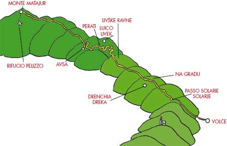
This route crosses the mountainside and therefore very worthwhile from a panoramic and historical point of view as it is totally immersed in the woods, apart from the mountains tops. This route starts from the Volče fields, near Tolmin/Tolmino and finishes on Matajur, the mountain on the border on top of Kobarid/Caporetto.
Description of the route
The Volče fields (San Daniele church) - Volče - Kamnica - Kovačič Planina - Pass Solarie/Solarje - Na Gradu (outdoor Slovenian museum) – Mount Piatto/Trinški vrh - Livške Ravne - Livek – hamlet of Perati (church of San Pietro e Paolo – Saints Peter and Paul) - Avsa - Idrska Planina (Mrzli vrh) - Matajur.
Length
The total length of the route is approximately
18km. Here are the kilometres for each section:
Volče - Na Gradu approximately 5km;
Na Gradu - Livške Ravne approximately 4km;
Livške Ravne - Livek approximately 3km;
Livek - Mount Matajur approximately 6km.
Altitude
Volče 198m;
Passo Solarie 996m;
Na Gradu 1115m;
Mount Piatto /Trinški vrh 1139m;
Livške Ravne 1037m;
Livek 690m;
Idrska Planina 1250m;
Matajur 1642m.
Level of dificulty:
Easy


 of Mengore, the fortified hill of the Austro-
Hungarian army in front of the bridgehead of
Tolmino. This hill, pointlessly besieged in all
the battles of the Isonzo, was never occupied by
the Italians. In the outdoor museum there are the
ruins of the trenches of the Austro-Hungarian first
line, used as artillery and observation posts.
of Mengore, the fortified hill of the Austro-
Hungarian army in front of the bridgehead of
Tolmino. This hill, pointlessly besieged in all
the battles of the Isonzo, was never occupied by
the Italians. In the outdoor museum there are the
ruins of the trenches of the Austro-Hungarian first
line, used as artillery and observation posts.
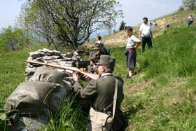
The area of Volče was one of the focal points from where the 12th Battle of the Isonzo started better known by Italians as the Battle of Caporetto. From here Erwin Johannes Rommel started his mission. He was a young (he was going to be 26 soon) lieutenant of the Württemberg Mountain Battalion, in command of three mountain divisions and of one machine gun division.
Departed from the Slovenian city of Kranj on the 18th October 1917, the Württemberg German troops reached the front on foot moving by night through the tunnel of the Transalpina railway line at Podbrdo and then along the Bača valley(Baška grapa) so as not to be seen by lookouts and Italian spies. Already during the night between the 22nd and the 23rd October 1917, Rommel was ready on the north side at the foot of Bučenica (a hill 509 metres high 1.5km south of Tolmino, visible from the church of Saint Daniel). The next night, a massive gun-fire (also with poison gas shells) starting at 2am, destroyed the first line of the front and wiped out the Italian units. On the 24th October 1917, at about 8am, the great Austro-German offensive started, from the posts at the foot of Bučenica. Rommel’s troops easily defeated the Italian first line of defence on the Volče fields, which were positioned near the church of Saint Daniel.
The itinerary continues on foot to the village of Volče and beyond; towards the north-west this tarmac road heads to the top of Mount Kolovrat, to Solarie/Solarje Refuge, where the road links with the one that comes from Kambreško. This path, which begins along the west slope of Mount Hlevnik, is not the precise route followed by Rommel with his troops; it is simply advised for commodity. To be precise Rommel, having passed the Italian first line at S. Daniele, started to climb Mount Hlevnik along the north-east ridge, using a path that leads to the Isonzo valley floor and the village of Foni where there was the second line of defence, in the direction of Hlevnik – Ježa. At about midday on the 24th October he occupied the top of Hlevnik (876 m.) and without fighting took almost all the Italian soldiers he could find as prisoners. From there he went towards the top of Kolovrat (1114 above sea level) where there was the highly fortified Italian third line of defence.
FROM ITAL Y: for those who want to reach Passo Solarie/Solare directly by car, at Cividale del Friuli take the main road n°54 in the direction of Caporetto. Arrived at Ponte S. Quirino/Muost (4 km), turn right onto provincial road n° 19 towards Savogna/Sauodnja. After approximately 700 metres, turn right onto the provincial road n°11 towards S. Leonardo/Podutana and Drenchia/ Dreka. Continue straight (passing Scrutto/ Škrutove and Clodig/Hlodič). Straight away after Lombai/Lombaj (22 km) at the junction turn left. After the hamlet of Prapotnizza/Praponca (3km) turn right towards Passo Solarie.
PASO SOLARIE/SOLARJE AND IL KOLOVRAT
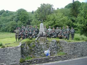 Arrived at Passo Solarie (intersection with
itineraries n° 1, page 20, n° 2, page 29, and n° 5,
page 49) between the two mountain border posts,
almost in front of the Italian Guard post, there is
a monument with a metal eagle on top in memory
of the first Italian who died in the First World
War. This was Riccardo Di Giusto, an Alpine
Troop from Udine of the 16th Company of the
Cividale battalion – 8th regiment. He fell at two
in the morning on the 24th May 1915, the first
day of war, in one of the first encounters with the
Imperial Austro-Hungarian Royal troops when
the Italian soldiers started the short advance that
brought the front to the bank on the right-hand side of the Isonzo river, in the valley below. The
research for finding the first fallen in the conflict
and the building of this monument was financed
by a public collection of funds proposed by Carlo
Gallardi Rivolta from Milan.
Arrived at Passo Solarie (intersection with
itineraries n° 1, page 20, n° 2, page 29, and n° 5,
page 49) between the two mountain border posts,
almost in front of the Italian Guard post, there is
a monument with a metal eagle on top in memory
of the first Italian who died in the First World
War. This was Riccardo Di Giusto, an Alpine
Troop from Udine of the 16th Company of the
Cividale battalion – 8th regiment. He fell at two
in the morning on the 24th May 1915, the first
day of war, in one of the first encounters with the
Imperial Austro-Hungarian Royal troops when
the Italian soldiers started the short advance that
brought the front to the bank on the right-hand side of the Isonzo river, in the valley below. The
research for finding the first fallen in the conflict
and the building of this monument was financed
by a public collection of funds proposed by Carlo
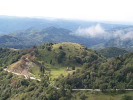
Gallardi Rivolta from Milan.Looking upwards at the monument from the front there are the steep slopes of the mountainous ridge of Kolovrat behind it which is on the bank on the right-hand side of the Isonzo river between Caporetto and Tolmino. This mountainous area marks the natural border between the Slavia Friulana and the high Isonzo valley. The state border between Italy and Slovenia runs along the summit of the tops of Na Gradu – Trinški Vrh (Monte Piatto) – Nagnoj and Kuk. Along this mountain ridge there is a beautiful panorama overlooking the Isonzo valley, dominated by imposing mountain tops (in front there is Mount Krn, better known as Monte Nero by Italians), and which streches from the Slavia and the Friulian plain to the Adriatic Sea on clear days.

Austro-Hungarian army showed that they would not be able to sustain another Italian offensive.
 For this reason the Austro-Hungarian command
decided to counter-attack, starting from Bovec,
Tolmino, Caporetto and beyond towards Cividale. In preparation for the 12th offensive of the
Isonzo, Germany with its forces came to the aid of
Austria-Hungary. The posts on Kolovrat (1114m
above sea level) for the Italian army were one of
the main places of defence in the 12th offensive.
To the Official that was to take hold of the
Austro-Hungarian command, the highest honour “Pour le merite” was promised. It was conferred
to the lieutenant Schörner who, with his unit, in
the German Alpenkorps, seized the positions of
Na Gradu already in the night of the first day of
the offensive. With numerous counter-attacks
the Italian army attempted to regain their lost
positions, but without success. In the occupation
of the top of Kolovrat Rommel also played an
important part with his unit. On the second day of
the offensive he was able to penetrate the Italian
defence lines on the top, approximately 800m east
of 1192 above sea level (Nagnoj); on the third
day of the 12th Battle of Isonzo with his unit he
occupied the top of Matajur.
For this reason the Austro-Hungarian command
decided to counter-attack, starting from Bovec,
Tolmino, Caporetto and beyond towards Cividale. In preparation for the 12th offensive of the
Isonzo, Germany with its forces came to the aid of
Austria-Hungary. The posts on Kolovrat (1114m
above sea level) for the Italian army were one of
the main places of defence in the 12th offensive.
To the Official that was to take hold of the
Austro-Hungarian command, the highest honour “Pour le merite” was promised. It was conferred
to the lieutenant Schörner who, with his unit, in
the German Alpenkorps, seized the positions of
Na Gradu already in the night of the first day of
the offensive. With numerous counter-attacks
the Italian army attempted to regain their lost
positions, but without success. In the occupation
of the top of Kolovrat Rommel also played an
important part with his unit. On the second day of
the offensive he was able to penetrate the Italian
defence lines on the top, approximately 800m east
of 1192 above sea level (Nagnoj); on the third
day of the 12th Battle of Isonzo with his unit he
occupied the top of Matajur.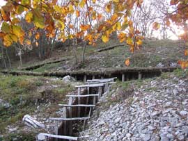 At this point the route can continue in different
methods: along two tarmac roads that touch the
ridge of Kolovrat, or along a path (red and white
Cai trail sign n° 746) that continues along the
mountainous chain tops. For those who choose
the tarmac roads continue on the north side of
Kolovrat, on the Slovenian side, or on the south on
the Italian side across the mountain border post at
Solarie/Solarje. Both roads lead to the foot of the
Na Gradu hill (known during the First World War
as quota 1114), where now there is an important
outdoor museum. On the Slovenian road this site
is marked by an Information board. On the Italian road, from Solarie/Solarje, after having gone up
along a bendy road, a little less than a kilometre,
take the wide and clearly visible path on the right
that goes, in a few metres, up to the small col
between the peaks of Na Gradu and Trinški vrh
(also called Passo Zagradan) and beyond which
there is the fortified site of Na Gradu.
At this point the route can continue in different
methods: along two tarmac roads that touch the
ridge of Kolovrat, or along a path (red and white
Cai trail sign n° 746) that continues along the
mountainous chain tops. For those who choose
the tarmac roads continue on the north side of
Kolovrat, on the Slovenian side, or on the south on
the Italian side across the mountain border post at
Solarie/Solarje. Both roads lead to the foot of the
Na Gradu hill (known during the First World War
as quota 1114), where now there is an important
outdoor museum. On the Slovenian road this site
is marked by an Information board. On the Italian road, from Solarie/Solarje, after having gone up
along a bendy road, a little less than a kilometre,
take the wide and clearly visible path on the right
that goes, in a few metres, up to the small col
between the peaks of Na Gradu and Trinški vrh
(also called Passo Zagradan) and beyond which
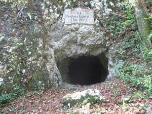
there is the fortified site of Na Gradu.For those who instead prefer the path on the Italian road after the first bend on the right there is the red and white Cai trail sign n°746. First the path climbs up the small peak of Na Gradu (also known as Mount Klabuk) and then descends on the plain below where there is the restored fortified site.


 than one floor dug in the rock and an interesting spiral staircase that links fortified posts with a tunnel below; and a thick network of linking trenches built on both sides of the border. These have all been rebuilt and are free to visit. The uniqueness of
this reconstruction is the fact that original materials
have been used from the First World War (such as
metal nets to reinforce slopes, corrugated iron, slate
stones). It is also possible to observe the frugal use
of cement which resulted in the poor resistance of
this fortification during the Battle of Caporetto.
This in fact fell during the evening of the first day
of the offensive, crushed from the heavy artillery
barrage and gas from the enemy.
than one floor dug in the rock and an interesting spiral staircase that links fortified posts with a tunnel below; and a thick network of linking trenches built on both sides of the border. These have all been rebuilt and are free to visit. The uniqueness of
this reconstruction is the fact that original materials
have been used from the First World War (such as
metal nets to reinforce slopes, corrugated iron, slate
stones). It is also possible to observe the frugal use
of cement which resulted in the poor resistance of
this fortification during the Battle of Caporetto.
This in fact fell during the evening of the first day
of the offensive, crushed from the heavy artillery
barrage and gas from the enemy.
The Slovenian part of the outdoor museum on the Kolovrat has been created by the institution “Fundacija Poti miru v Posočju” (foundation “Paths of Peace in the Isonzo valley”) of Kobarid/ Caporetto as the information board positioned next to the road explains. Here, during the First World War an important main supply route passed that linked the zone behind the trenches with the Italian positions on the bridgehead of Tolmino, or to be precise the first and second lines.
In fact, looking at the northern Slovenian side from the ridge, it is possible to see, in a few areas, the difficulties in watching the steep ground immediately underneath in front of the Third line of defence. Rommel took advantage of this fact for his silent infiltration. There are two important points which mark the success of the German lieutenant on the Italian Defence lines who were feared by their enemies. 800 metres east from Mount Nagnoj, in a small col, Rommel’s men were able to infiltrate into the Italian trench surprising the soldiers as they were sleeping because they were convinced that they were still far from the centre of action. This manoeuvre allowed Rommel to advance, taking advantage of the actual trench, up to Nagnoj and then he took advantage of the road open to heavy traffic on the Italian side. The festoons, with which this was masked so as to hide the movements on the Austro-Hungarian troops also protected the German soldiers that advanced going round the Italian defences on Nagnoj and on Mount Kuk. On this latter peak, the trenches were innocently created – Rommel himself stated – looking only towards the Isonzo valley and did not adequately control the road open to heavy traffic behind. When the Italians realised Rommel’s infiltration, they hastily attempted to build trenches on the eastern side of Mount Kuk, but because of the rocky ground they were not able to and they remained under the fire of the Württemberg gunmen. This same rocky ground amplified the effect of the Austro-Hungarian weapon fire as it discharged a precipitation of stones and debris on the Italian infantry, supporting the actions of Rommel. If they had been Trenched on the opposite side of Mount Kuk, protected from the outline of the mountain, the Italian troops – Rommel himself admitted – would probably have been able to permanently stop his advance.
Turning instead onto the tarmac roads that go round the tops of Na Gradu and Trinški vrh, both link up on the Slovenian side and continue to Livške Ravne and further on up to Livek.
closed at the bottom by a barrier: in order to go by car it is therefore necessary to return to the border post of Solarie/Solarje and from there take the parallel road on the Slovenian side. It is probable that with the entrance of Slovenia in the Schengen Treaty (December 2007) the barrier will be removed. But it is better to make sure beforehand by asking at the Solarie Refuge.
Livek
Livške Ravne is one of the highest villages above
sea level in Slovenia. Zgornje Ravne is 1050m
above sea level. Right next to the road, on the
left there is Dom Kavka, a small ex-barrack
transformed into a summer and winter camp
for youngsters where they do school and extracurricular
activities.
The tarmac road continues therefore towards Livek. This is not the road Rommel took; from Ravne he cut through the woods in order to
reach Polava, which was in Italian territory along the road that joined Livek with Cepletischis/Čeplešišče (commune of Savogna/Sauodnja, in Italy). There, with a small group of men, they blocked this fundamental route of withdrawal for Italian troops, seizing a large amount of arms and vehicles and also a few thousand prisoners.
Between Livške Ravne and Livek, on the right-hand
side of where there once was a hostel for skiers,
there is now a new tourist complex of apartments:
Nebesa. Where there were once ski slopes now
dears graze in a fenced area.
Livek and the villages nearby up until 1814 were part of the Republic of Venice. This is evident by the boundary stone near the village of Golobi on which there is the coat of arms of the Republic of Venice and of the Hapsburgs. Livek went under Austrian domination in the 19th Century.
Here it is possible to visit the church of San Giacomo (Saint James) which is one of the eldest in the territory and was part of the Patriarch of Aquileia. It dates from the 16th Century. Next to the church there is a huge lime tree that has been there for over 400 years.
In the village of Golobi (house number 5) it is possible to visit a private museum of the First World War where the events of the Italian Third Line of defence are presented. For over ten years the owner, Peter Hrast gathers, mainly on Kolovrat, relics and findings of the First World War. In his museum he has over a thousand pieces on show.
The route continues along the old road of Livek leaving from the village. The indications put in front of the school directs towards the right.
Following the trail sign through the woods you reach the church of SS. Pietro e Paolo (Saints Peter and Paul). According to the inscription on the stone of the bell tower it is said to have been built in the 16th Century (1540).
MOUNT MATAJUR
The road continues from Livek through Perati up to Avsa (860m.). Excursionists have at this point two routes for climbing Matajur.
FIRST ROUTE: Just before the village of Avsa turn right along a narrow cart road which then turns into a path. The route goes through a wood and a number of meadows. Following the indications, after approximately an hour’s walk, you reach Idrska Planina under Mrzli vrh (1359m.)
SECOND ROUTE: Follow the road that goes through Avsa and after approximately 500 metres indications direct to the right. After about an hour’s walk through fields and woods, following the trail signs, you reach the dirt road under Mrzli Vrh. From Mrzli Vrh continue along the dirt road up to the basin/fountain of Tršca. From here there is a path that divides into junctions; both paths lead to the top of Matajur. The one to the right is a little steeper and passes on the Slovenian side, the one to the left runs along the ridge and is mainly on Italian territory.
ALTERNATI VE ROMMEL TO GO UP MATAJUR (ON FOT, BY BIKE OR ON HORSE)
further, for approximately 200m, on a dirt track. A signboard marks a restored trench at the top and at the bottom of the road; the inside can also be visited. At the top the renovated section is rather short; at the bottom it leads to Jevšček (calculate about an hour to cover this section and to return). After having passed this obstacle, Rommel went to the now Italian territory under Mount Kraguonca and then towards Mrzli Vrh and Matajur. Rommel again states many times in his diary “Infanterie greift an” the harshness and difficulty to climb Matajur.
An alternative road, nearer to that of Rommel, is advisable only for those who from Livek can go by car. Continue towards Italy (direction Cepletischis/Čeplešišče) passing through the small villages of Šturmi and Polava. Approaching this last village, it is possible to imagine the surprise of the retreating Italian soldiers from Livek seeing, from behind a bend, the German Alpine men and the Württemberg gunmen appear all of a sudden on a road behind the lines that should have been safe. From Cepletischis/Čeplešišče take the road towards the peak of Matajur; leave the car in the village of Masseris/Mašera. From here take the path marked with the red and white CAI trail sign n°736 that joins Rommel’s path after Jevšček. There is a shorter alternative (marked with the red and white Cai trail sign 736A) but it goes more towards the west of the route Rommel took.
ALTERNATI VE BY BIKE OR ON HORSE TO GO UP MATAJUR
Cross the village of Avsa and after approximately 1km the tarmac road ends. Continue along a relatively flat dirt road, an Italian military road that passes Planina Sleme and a crossroad under Mrzli vrh. The path on the right leads to Idrska Planina, whereas that on the left turns towards the bottom for the first brief section and then starts to go up. The road finishes near Tršča. From here up to the top of Matajur continue on foot. We advise the Italian road. It takes approximately 20 minutes to reach the top.
ALTERNATI VE BY CAR, BIKE OR ON HORSE TO GO UP MATAJUR
From Livek go towards the border posts passing through the village of Šturmi. Continue passing the villages of Polava and Cepletischis/Čeplešišče. Here at the junction turn right towards Masseris/ Mašera and Montemaggiore/Matajur (955m) then go up to the Pelizzo Refuge (1320m). From here you reach the top of Matajur on foot.
FROM ITAL Y: for those who want to reach the top of Matajur directly by car, from Cividale del Friuli take main road n° 54 in the direction of Caporetto. Having arrived at Ponte S. Quirino/Muost (4km), turn right onto provincial road n°19 up to Savogna/Sauodnja (8km), then continue up to Cepletischis/Čeplešišče (6km), Montemaggiore/ Matajur (6 km) and then always continue straight to the Pelizzo refuge. From here a path easy leads up to Matajur on foot.
On its southern side the villages of the Slavia are dispersed. From its top, when the sky is clear, it is possible to see southwards beyond the Slavia to the sea and north-west up to the Dolomites. On the Slovenian side there is an extraordinary view overlooking the Alpi Giulie and the Isonzo valley. On the top of Matajur there is the state border. From the 1st May 2004 Slovenia became member of the European Union and right next to the boundary stone on Matajur and then at the Pelizzo Refuge on that day there was a big exhibition. On the top there is an interesting chapel of Cristo Redentore.